Red arrow pointing to Packman’s Road and where the spa ponds should be on the Thomas Joseph Ellis Map of 1824-25.
While one medieval map mentioned Peel Waters in the vicinity of Spa Ponds, we are not aware of any actual ponds being clearly depicted on any map until the 1830’s. Many of the older maps showing the area of Spa Ponds were not very detailed and so not too much can be read into the omission.
The Ellis Map of 1824-25 (published in 1831) was in sufficient detail to show both the pond above the warren and Packman’s Road, yet does not depict any ponds to the east of Packman’s Road. On the other hand, we are aware of instances where Ellis glosses over elements such as minor paths contained in more detailed mapping.* As such, while Ellis provides some indication that there were not clearly visible ponds at Spa Ponds in 1824-1825, on its own this is not strong evidence.
However, as discussed later there are reasons to think that the first iteration of the modern ponds at Spa Ponds were constructed or reconstructed shortly after the Ellis map was surveyed as part of the creation of the Duke of Portland’s water meadows and flood dykes, and this increases the possibility of Ellis being right not to show ponds at Spa Ponds in 1824-25.
Clear evidence of ponds at Spa Ponds from 1830-1834 survey
Spa Ponds shown on George Sanderson’s map of Mansfield, 1835. Fuchsia overlay shows modern Packman’s Road and Spa Lane.
As shown above, the ponds at Spa Ponds appear on George Sanderson’s map of Mansfield published in 1835 which would have been based on surveys from 1830-1834 and the first detailed Ordnance Survey map of the area from a survey from 1824-1840. They also show the Spa Lane bridge over the flood dykes to the north of Spa Ponds. Two ponds are shown at Spa Ponds to the east of Packman’s Road where one would expect.
Clipstone Water Meadows and Flood Dykes
If you look at the above maps you will see they refer to Water Meadows and a flood dyke. These would have been brand new at the time, as they were constructed for the Duke of Portland around that time.
John Evelyn Dennis, Esq. wrote about the Water Meadows at Clipstone Park in 1840, stating:
“The eye, after wandering through the glades of the forest, and resting on the brown carpeting of fern and heather with which it is clothed, is amazed on coming suddenly in view of the rich green of the meadows, extended for miles before it, laid in gentle slopes and artificial terraces, and preserved in perpetual verdure by supplies of water continually thrown over their surface. The land immediately occupied by these meadows was in its wild state a line of hill-sides, covered with gorse and heather, -a rabbit-warren, over which a few sheep wandered,- and a swampy valley below, thick set with hassocks and rushes, the favourite haunt of wild ducks and snipes through which the little stream, the Maun, wound its way in its descent from the town of Mansfield.”
The whole track, both upland and lowland, was of very little value. The valley was in many parts from 9 to 10 feet deep in bog, and almost worthless; the hill-sides varied in quality… In the year 1819 it occurred to the Duke of Portland that by following the stream up towards its source, and tapping it at a high level, the water might be carried over the surface of the dry and sterile hills, its course through the valley might be straightened, and the bog drained.”
“”
Maps of the area prior to 1835 do not show any ponds at Spa Ponds.
Notes, sources and further readig:
* For example, if one compares the detailed 1791 Crown Survey map of Birklands and Bilhaugh to the south-east of Spa Ponds with both the Ellis map and the detailed 1840 OS Map one can see many features such as minor paths and the centre tree which appear on those more detailed maps but are absent from the Ellis map).
Dear Member / Supporter of the Forest Town Nature Conservation Group (FTNCG),
I write to formally notify you of FTNCG’s rescheduled 2018 Annual General Meeting (AGM).
This meeting will be open to the public, and the formal business of the AGM will be followed by a short break and then a presentation and discussion about the fungi to be found at Spa Ponds with Ann Ward of the Nottinghamshire Fungi Group.
Date, time and place of the AGM:
Saturday 1st September 2018, from 10am at the Flint Avenue Community Centre (see attached directions).
General nature of business to be transacted:
1) Report and Accounts (including finance report / Annual Statement of Accounts)
2) Election of Officers and Trustees
Membership Renewal / Joining FTNCG:
The AGM will also provide a good opportunity to renew your FTNCG membership, or to join FTNCG (£5 suggested donation, waivable upon request).
Thank you for your ongoing support for the Forest Town Nature Conservation Group.
Yours sincerely,
Shlomo Dowen
Chair of the Forest Town Nature Conservation Group
https://www.foresttown.net/nature
Please join us at Spa Ponds for our next work session, starting at 10am on Saturday 19th May. Be sure to wear sturdy shoes and long sleeved shirts.
The plan is for Rich to be with us and he intends to help us identify some of the amazing wildflowers we have on the site. We will also be progressing with the preparations for planting as part of the Wetland Habitat Recreation Project, e.g. by clearing bramble near Pond 1.
The Spa Ponds Heritage Project was established to investigate, celebrate and protect the heritage of Spa Ponds Nature Reserve in Forest Town, Mansfield, and is supported by a Heritage Lottery Fund Sharing Heritage grant of £8,500.
On Friday 7th July 2017 James Wright delivered a Mediaeval Landscape Day School for the Spa Ponds Heritage Project. Shlomo and Josh’s account of the day is below:
The Day School was entitled: ‘Kings, Knights and Knaves of Clipstone – A Day School Exploring The Mediaeval Landscape of Sherwood’, which was a fitting title, as author and archaeologist James Wright provided participants with a four-in-one treat in the form of a comprehensive Day School that featured:
A seminar exploring the definition of a castle;
A lecture focusing on elite landscapes;
An engaging seminar about Mediaeval hunting; and
A lecture that looked at the theme of revolt against authority in the 14th and 17th centuries at Clipstone.
Seminar – What is a castle?
What is a castle? We’re about to find out that this simple question is a rich topic of debate and study…
Spa Ponds sits within, or alongside, the Mediaeval context of Clipstone Peel, a fenced enclosure on the edge of Clipstone Park. Our knowledge of the peel site from Mediaeval sources and modern analysis of the political situation at the time indicate that the peel was intended, at least in part, to provide a secure location for the king to reside during a time of political strife (in particular King Edward II’s ongoing feud with Thomas, Earl of Lancaster). Because of this, Clipstone Peel shared many features and purposes in common with medieval castles.
We began the day by identifying some of the castles that we had visited, and James impressed us all with his intimate knowledge of so very many castles. This was the prefect start to our consideration of the basic but tricky question: “What, pray tell, is a castle”?
For example, the building at Bolsover has been rebuilt – is it still a castle? And what of the construction at Disneyland – although it is clearly an attempt to reflect an archetypal castle – does it meet the definition of a castle? What qualities need to be present for a structure to constitute a ‘castle’?
Language matters. People say a castle is built by this king or that king, but in reality it is the labourers.
James noted that castles are built for not by royalty and others. We discussed who commissioned castles to be built and we generated a list that included: kings and queens; other royalty (such as dukes, barons, gentry, and other aristocrats, e.g. in Wales); and other landowners, including magnates (e.g. Henry Percy), statesmen (e.g. Ralph Cromwell); knights; The Church and associated religious orders and bishops, e.g. fortified structures at priories, and Newark Castle (Alexander the Magnificent was a bishop). Vikings built fortifications for their armies, crusaders built castles, and some castles built for wealthy merchants, e.g. Lawrence de Ludlow.
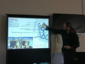
Key castle defensive features such as ditches and drawbridges were explained with reference to Conwy Castle in Wales.
We went on to consider the sorts of buildings and rooms and architectural features found in castles, and how many of these are reflected in contemporary buildings to this day. All these considerations helped frame the tricky question: Are castles built primarily for military purposes or to provide a residence, or both? We identified plenty of non-military uses of castles, thus ruling out the notion that castles are (or were) exclusively built for military purposes, even if they inevitably reflect “an architecture of power”.
Crenellations were used for the military purpose of having gaps to shoot arrows through. However, such “trappings of fortification” were also used for symbolic purposes as an architectural feature. Projecting power was itself considered to be serving a strategic purpose and as such there was a blurred line between the ‘symbolic’ and the ‘functional’.
Lecture – Elite Landscapes: Beyond the Castle Gate
James’ lecture on elite landscapes drew our attention to the deliberate relationship between windows, nearby gardens, and the larger landscape context (park land) that can be seen further afield. James pointed to the religious influences, whilst noting that castles were sometimes but not always located near churches.
We learned about the classic motte-and-bailey castle design, with James explaining that a motte is a mound of earth and a bailey is an enclosure. Castles are located at high points in the landscape, e.g. Bothamsall on Castle Hill on a former Saxon enclosure with the motte in the middle.
James explained that the positioning of a castle on high points either side of the King’s Highwya meant that they would be a visible expression of power to those who came and went. The treaty between the Earls of Leicester & Chester (c. 1149-53) limited the castles that those Earls held held, affecting the subsequent distribution of castles in the area.
The building of a castle sometimes required the clearing of woodland to create lawns (including deer lawns). The landscapes within which castles are located include both functional and symbolic elements. Good landscape management was associated with good management of the kingdom as a whole.
The royal hunting land of Clipstone Park was thought to have been a key part of the visual and symbolic landscape of King John’s Palace, known as the King’s Houses, with the ‘wilderness’ of the forest contrasting with the more managed gardens of the palace complex.
Seminar – An examination of Mediaeval hunting with reference to Sir Gawain and the Green Knight
James introduced us to the 14th Century poem on hunting that we needed to dissect.
James’ creative approach to teaching made use of poetry, in particular selected passages from Simon Armitage’s contemporary translation of Sir Gawain and the Green Knight, to help us appreciate what went on at deer parks, such as the one at Clipstone Park. Again the symbolism was apparent, with lording it over the deer and lording it over the landscape representative of the ruler’s power – hence the association between hunting and the aristocracy.
Participants were split into several small groups to facilitate our close consideration of James’ carefully selected excerpts from Sir Gawain and the Green Knight. This process introduced us to a series of fairly gruesome words and images, such as “numbles” (entrails), “gralloching” (disembowelling), and other terms associated with the ritual butchering of deer killed in the hunt.
It became abundantly clear that the many rituals and customs associated with Mediaeval hunting served to reinforce the social order. For example, social status determined which cuts of meat were given to whom, with the hunting dogs shown preference over and above the local villagers. There was also evidence of superstition, such as the reference to paying a ‘fee for the crows’.
Whilst aristocratic hunting was not a very practical means of gathering food, in addition to its social function it did also serve the additional purpose of helping to train horses and men to be better prepared for warfare. The hunting techniques employed required planning, coordination between participants, and the ability to function on difficult and noisy terrain.
Lecture – Royalty, Rebellion and Revolution in Sherwood Forest
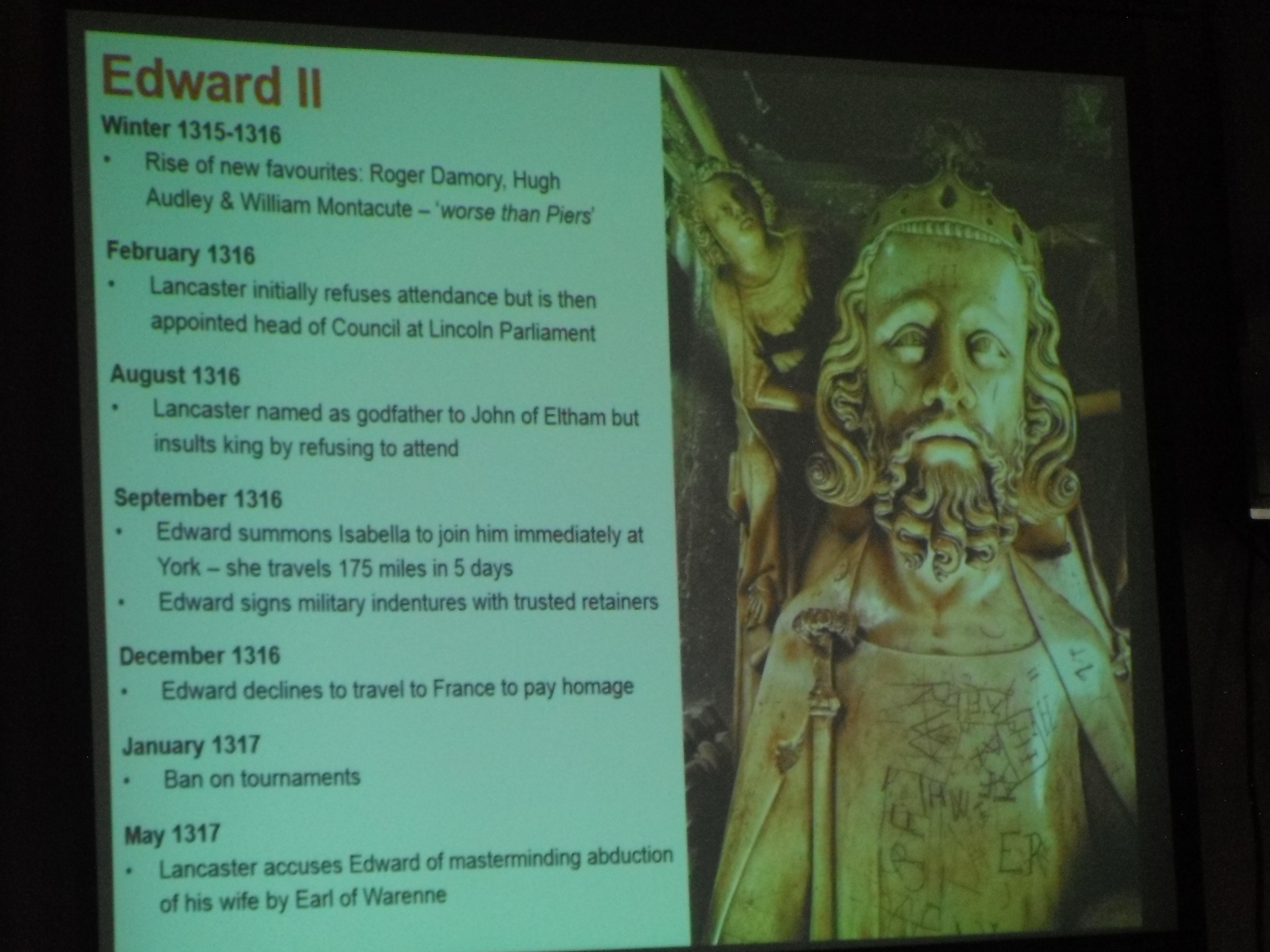
James’ lecture entitled ‘Royalty, Rebellion and Revolution in Sherwood Forest’ looked at the theme of revolt against authority in the 14th and 17th centuries at Clipstone. The 14th century focus was on Edward II, the peel and Robert de Clipstone. The 17th century focus was on revolution, recusants and witches. A recusant is a person who refused to attend services of the Church of England.
James noted that the first written record of the Kings Houses at Clipstone being described in as “King Johns Palace” was Chapman’s map of Nottinghamshire (1774).
Edward II had a great love of hunting, and timed his visits to Clipstone to correspond with deer hunting seasons. He was not universally respected, as he was seen as weak. Edward II lost the Battle of Bannockburn to the Scots in June 1314, and his power was diminished by this defeat. This added to his problems with Thomas, Earl of Lancaster.
Edward II often visited the Kings Houses during the hunting seasons of the various deer that were at Clipstone Park. Some of his out-of-season visits were associated with times of difficulty when the King may have been seeking a reliable retreat or refuge.
Edward II’s ban on tournaments was described as another sign of his weakness, as Edward II needed to maintain control during his turbulent reign. This adds to the notion that Edward II had the peel (fortified structure) at Clipstone built as both a defence (against Thomas, Earl of Lancaster) and to provide Edward II with a place to hide if need be. There is some evidence that Edward II stayed at the Peel rather than the Kings Houses in order to be safer from Thomas, Earl of Lancaster.
Edward II in a time of turmoil during which he commissioned the creation of Clipstone Peel.Items and buildings known to have been at Clipstone Peel include many elements typically found at castles and indicated a fortified area that also supported local agriculture.
Edward II may have fled the country, despite reports that he was murdered in Berkeley Castle. Whatever the case, it is universally accepted that Edward II was forced to relinquish his crown in January 1327, when his fourteen-year-old son, Edward III, became king (at least in name). It is thought that the true power during the start of Edward III’s reign was his mother Isabella and her lover Roger Mortimer.
The turbulence of these times may help explain the boldness of the local people who rose up to petition the King to return to them the land rights that were taken away when the Peel was erected and lands taken for the King for the Peel and adjacent farmland. Robert de Clipston is recorded as having been one of the original petitioners in relation to the peel was also the “keeper of the manor and park of Clipston” in 1328, when the Peel was dismantled early in the reign of Edward III. Some of the disputed land might have included the area we now know as Spa Ponds.
Local protested against the creation of Clipstone Peel on land they were using for various useful purposes (as well as the seizure of property such as cattle to support the Peel).Historical records state that Edward II stayed at Clipstone Peel during a period of particular peril. However, the Peel complex was dismantled after the subsequent downfall of Lancaster and the succession of Edward III to the thrown.
A full account of the petitioning and subsequent throwing down of the Peel is included within Jame Wright’s “A Palace For Our Kings“.
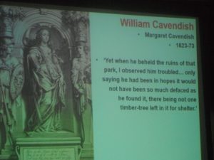
In ‘The Life of William Cavendish, Duke of Newcastle’ (published 1667) Margaret Cavendish spoke of the desolation of Clipstone Park after her husband William fled to France in Exile during the Civil War and the trees were taken to fuel a forge and as a source of timer for ship building.
In the 17th Century there was a spike in the number of recorded recusants (i.e. those not attending church and instead submitting to the authority of the Pope) and an apparent increase in the number of ritual protection marks, reflecting the social tensions of the times.
There is the possibility that Beeston Lodge was named after the family of Thomas Beeston Senior who was a Nottinghamshire yeoman and 17th century recusant.
Notable spike in recusancy in Clipstone.Historic ritual protection marks were found in buildings in King’s Clipstone.
MORE ABOUT JAMES WRIGHT
James Wright FSA is an archaeologist and historian who is currently a doctoral researcher at the University of Nottingham With over twenty years of professional experience, he has published two books and a string of popular and academic articles concentrating on the British Mediaeval and Early Modern periods. He is a very proficient public speaker and has spoken to a wide variety of organisations including a large number of local history societies, LAMAS, Thoroton Society, WEA, Thames Discovery Programme, Nottinghamshire Local History Association, U3A, Lowdham Book Festival and the Fortean Society. He has also been invited to speak by the University of Nottingham, Gresham College, Shakespeare, Museum of London, Historic Royal Palaces and the National Trust. He presents in a clear and conversational style (without notes or script) and readily uses illustrative slides throughout his lectures. The talks are adaptable and can be presented to novice, mid-level or expert audiences.
For yet more, see: http://nlha.org.uk/news/james-wright/ and http://www.triskelepublishing.com/jameswright/
FTNCG are hosting a LIDAR Workshop this coming Saturday 11th March (10am – 3pm). This free Workshop is made possible by the Heritage Lottery Fund, and will take place at the Flint Avenue Community Centre in Forest Town.
The LIDAR Workshop with David Astbury of MBArchaeology will provide an introduction to the use of LIDAR surveying in archaeology. The Workshop will cover the aims and purpose of LIDAR surveys, how they are undertaken, what they can reveal and how archaeologists use this information. We will also look at the LIDAR results for Spa Ponds and the surrounding area.
If you wish to attend and are not already a registered ‘Project Participant’ or member of the Forest Town Nature Conservation Group then please get in touch with us via spa.ponds@gmail.com to ask about registering in advance of the workshop.
Those attending are advised to bring a packed lunch and to arrive 15 minutes early (9:45am), so that the Workshop can start promptly at 10am.
The next Spa Ponds Heritage Project Workshop will take place at the Flint Avenue Community Centre on Saturday 25th February (with participants arriving from 9:30am for a 10am start and 3pm finish), when Matt Beresford of MBArchaeology will provide us with some History Research Skills Training. A map to the venue is available upon request, and is recommended if you have not been there before.
Those who have not attended previous Project events are welcome to join us at this point. If you are not already registered as a project participant then to book your place on this workshop please e-mail: spa.ponds@gmail.com
The History Research Skills Workshop will explore the various historical resources that are available, how to use them and where to locate them. The training will include documentary sources, paleography, books/journals, online media, illustrations, and information stored in local archives. These research skills will help us with our work looking into the heritage of the Spa Ponds Nature Reserve.
All the events that are part of this project are free to attend. Refreshments will be available, but you are advised to bring your own lunch.
Please share this invitation with others who might be interested.
The Facebook event is at https://www.facebook.com/events/1392659110766409/
Notably, the LIDAR Workshop will now take place on Saturday 11th March, with the Maps Workshop being moved to Friday 21st April, and a new session focusing on sharing photographs and memories scheduled for Saturday 1st April.
All of the events included on the Diary Dates page handout are free to attend. Most of them are only for project participants or for those who have pre-booked. If you have not already booked your place and you are interested in any of these activities please contact us via: spa.ponds@gmail.com
A number of places are left for the Spa Ponds Heritage Project’s Introductory Workshop, which will take place from 9:30am on Saturday 14th January 2017. As with all other project activities this workshop will be free of charge.
The Workshop will feature a series of brief introductions to various elements of the Project, including Shlomo describing the Heritage Management Plan, Mark talking about ‘Time Travelling with Trees’, and Ann explaining what sharing ‘oral histories’ entails.
The remainder of the Workshop will be led by MBArchaeology’s Matt Beresford who will provide an overview of the training that MBArchaeology will be providing throughout the project.
Matt, an experienced tutor and community archaeologist, is an Associate Member of the Chartered Institute for Archaeologists. He qualified from the University of Nottingham with an honours degree in Combined Studies (Archaeology & History) and a Masters degree with Distinction in Local & Regional History. He is currently undertaking Doctoral research through the University of Hertfordshire.
The Introductory Workshop will be a real treat for all those who attend, and will help position participants to contribute to the Spa Ponds Heritage Project.